
Play Humberto Forms: Coastal Threats For US, Bermuda
Tropical Storm Humberto has formed in the Central Atlantic and Imelda is likely to follow soon. Humberto is likely to remain away from the mainland United States, but the interest area we are watching for Tropical Storm Imelda could pose a larger threat to parts of the Southeast U.S., the Bahamas and Bermuda as the Atlantic Basin's active period continues following Hurricane Gabrielle.
There is still considerable uncertainty as to the details of how this will all shake out into next week, so please check back with us at weather.com for important updates in the days ahead as the forecast gradually becomes clearer.
Here's our latest thinking, including a potentially weird wild card to the forecast.
Newly-formed Tropical Storm Humberto To Near Bermuda
Tropical Storm Humberto is several hundred miles east-northeast of the Leeward Islands.
Models suggest that it will strengthen into a Category 2 or 3 hurricane that could be of some threat to Bermuda early next week, but is unlikely to be a U.S. threat.
Bigger Concern For The U.S. East Coast
A tropical wave currently moving through the northeast Caribbean — designated as Invest 94L — will bring showers with locally heavy rain to Puerto Rico and the Virgin Islands through early Friday, then Hispaniola, eastern Cuba and the Bahamas.
(MORE: What An 'Invest' Means In Hurricane Season)
Current Radar
From here, the system will head westward across the Dominican Republic, Haiti and the Turks and Caicos in the next couple of days. There, it will bring heavy rainfall and gusty winds.
This system, which would be named Imelda, is most likely to form by this weekend when it's somewhere near the Bahamas in the red zone on the map below.
NHC Development Chance (The possible areas of tropical development according to the latest National Hurricane Center outlook are shown by polygons, color-coded by the chance of development over the next seven days. An "X" indicates the location of a current disturbance. The forecast cone of an active tropical system is also shown. )
There is a lot of uncertainty in the forecast for this system.
Advertisement Some computer forecast models pull this system north near or over and western Bahamas and off the Southeast U.S. coast from Florida to North Carolina early next week. It may either stall offshore for a few days or landfall some time Monday - Tuesday. It may either be a tropical storm or hurricane at that time.
Most of the models eventually pull this system eastward into the Atlantic by mid-late next week, but that eastward movement could propel it toward Bermuda, meaning it could be the second system to affect Bermuda in just a few days' time next week.
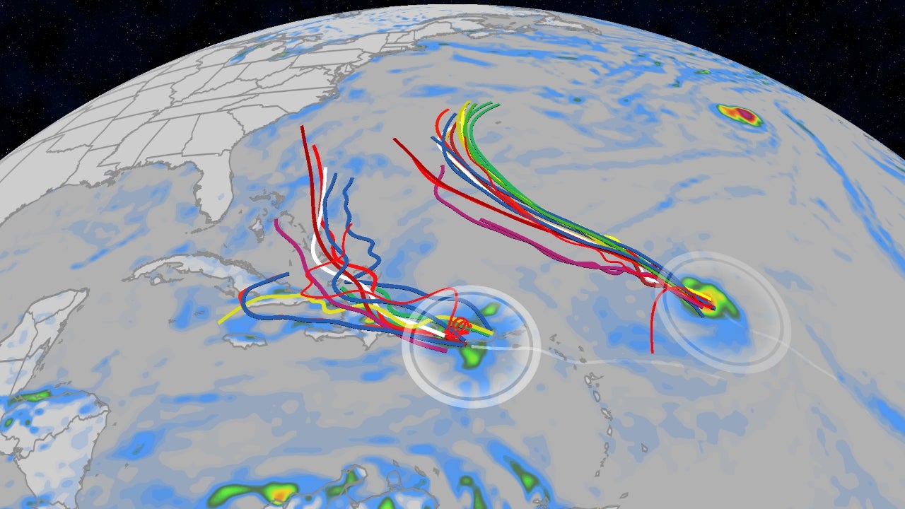
Spaghetti Models for the Invests (Invest 94L is to the west and Invest 93L is to the right)
Even if this system doesn't ever make a landfall in the U.S., days of onshore winds are likely to generate dangerous high surf, rip currents and at least some coastal flooding up and down the Eastern Seaboard from Florida to New England next week.
All interests in the Bahamas, the U.S. East Coast (especially from Florida to North Carolina) and Bermuda should closely monitor the progress of this forecast.
As usual for late September, there is plenty of deep, warm ocean water that could fuel tropical development in this area, as was the case with Hurricane Gabrielle.
Ocean Heat Content (This map shows areas of not only warm water, but warm, deep water that is one ingredient to fuel developing and active tropical cyclones. The two areas of possible tropical development are also shown as red Xs and polygons. )
A Weird Possibility
One other outcome suggested by some computer models is that both systems could be close enough to each other to do a kind of circular dance, what meteorologists call the Fujiwhara effect.
Sometimes the larger system can grab hold of the smaller one and absorb it. Other times, both systems can creep closer and spin around each other before going on their own paths.
This happened in recent years most often in the Pacific Basin, including last year with tropical storms Emilia and Fabio.
We'll keep an eye on this possibility in the coming days and spell out what it could mean for you if this "dance" becomes imminent.
Check back with us at weather.com for the latest on these systems.
[SRC] https://weather.com/storms/hurricane/news/2025-09-23-two-tropical-storms-could-form-us-bermuda-humberto-imelda


