
Tropical Storm Imelda Threatens U.S. Southeast as Hurricane Humberto Intensifies
The U.S. Southeast is bracing for potential impacts from a developing weather system expected to become Tropical Storm Imelda, while Hurricane Humberto has intensified into a powerful storm in the Atlantic. State of emergency declarations have been issued in both North and South Carolina as officials urge residents to monitor weather conditions closely.
Imelda's Projected Path and Potential Impacts
As of Saturday, the system identified as Tropical Depression Nine is expected to strengthen into Tropical Storm Imelda. Forecasters predict it will move northwest toward the Bahamas and Florida before potentially impacting the coasts of Georgia and the Carolinas. The National Hurricane Center has issued tropical storm watches for parts of the Florida coastline. Residents are advised to prepare for heavy rain, strong winds, and possible flooding.
- South Carolina Governor Henry McMaster urged residents to closely monitor the weather and stay alert.
- North Carolina Governor Josh Stein declared a state of emergency in advance of the approaching system.
- The storm could bring high winds and heavy rain, potentially leading to significant flooding.
Hurricane Humberto's Strength and Location
Meanwhile, Hurricane Humberto has intensified into a major hurricane, reaching Category 5 status. While not currently considered a direct threat to the U.S. mainland, Humberto's swells are expected to cause dangerous surf and rip currents along the East Coast. As of Saturday, Humberto was located northeast of the Leeward Islands, moving northwestward.
The National Weather Service has issued advisories for coastal areas, warning of the risks associated with strong rip currents and high surf. Mariners are advised to exercise caution.
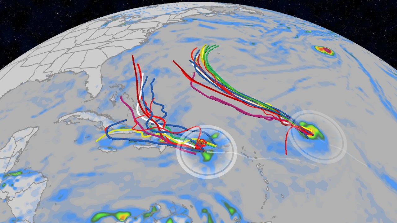
The Fujiwhara Effect: A Complex Forecast Scenario
Meteorologists are also monitoring the potential for a Fujiwhara effect, a phenomenon where two cyclones in close proximity begin to interact, altering their paths and intensities. This interaction between Humberto and Imelda adds uncertainty to the forecast, making it challenging to predict the storms' future movements.
"The Fujiwhara effect is a phenomenon that occurs when two cyclones near each other begin to spin around a common center point between them rather than moving independently," - Brian McNoldy, a senior research associate at the Rosenstiel School of Marine, Atmospheric and Earth Science at the University of Miami.
Other Weather Systems in the Atlantic and Pacific
The Atlantic isn't the only ocean experiencing tropical activity. Post-tropical cyclone Gabrielle is moving away from the Azores, while in the Pacific, Hurricane Narda, although weakening, is generating swells affecting coastal Mexico and Baja California Sur, with potential impacts on Southern California.
Preparedness and Monitoring
State and local officials are taking precautionary measures, including prepositioning search and rescue teams and preparing for potential flooding. Residents in affected areas are urged to stay informed, heed warnings, and have an emergency plan in place. This includes people from the Carolinas, to the Bahamas, to Florida.
Rainfall and Potential Flooding
Heavy rainfall is a major concern across the Southeast. Coastal southeastern parts of North and South Carolina could see between 5 and 10 inches of rain through the first couple of days of October, while some locations could see upward of 8 to 16 inches, according to AccuWeather meteorologists. Such amounts can lead to "widespread life-threatening flooding, especially if the storm slows down or stalls”.